NE Provenance
Solutions
Intelligence
Pricing
Partnerships
Local
About
Contact
Property Search
NE Provenance

The authoritative property intelligence platform for New England.

Product

  • Property Search
  • Account
  • Intelligence
  • Pricing
  • Partnerships
  • Local Insights
Solutions
  • Insurance Carriers
  • Underwriting & Modeling
  • Claims & Loss Control
  • Appraisers
  • Home Inspectors
  • Lending
  • Title & Legal
  • Agents & Developers
  • Property Lists
  • Portfolio Intelligence
  • Research & Academic

Company

  • About
  • Contact
  • Privacy Policy
  • Terms of Service
  • Acceptable Use
NE Provenance

The authoritative property intelligence platform for New England.

Product

  • Property Search
  • Account
  • Intelligence
  • Pricing
  • Partnerships
  • Local Insights

Company

  • About
  • Contact
  • Privacy Policy
  • Terms of Service
  • Acceptable Use
Solutions
  • Insurance Carriers
  • Underwriting & Modeling
  • Claims & Loss Control
  • Appraisers
  • Home Inspectors
  • Lending
  • Title & Legal
  • Agents & Developers
  • Property Lists
  • Portfolio Intelligence
  • Research & Academic
AES-256 encryption
US-hosted infrastructure
CCPA compliant
Customer data never sold or shared
Authoritative, primary sources
PostgreSQL — enterprise-grade infra

© 2026 New England Provenance LLC. All rights reserved.

Property intelligence derived from 140+ data sources. Data, methodologies, and analytics are proprietary.

428 Lafayette Rd., Suite 101, Hampton, NH 03842

[email protected]
New EnglandMassachusettsConnecticutNew HampshireRhode IslandMaineVermont

Local Insights/Maine

Maine property intelligence

NE Provenance tracks 256,988 properties across 2 Maine counties and 57 municipalities — with 430+ intelligence attributes per parcel assembled from 140+ independent data sources. The median Maine property dates to 1977, with the oldest on record to 1700.

Portland, Maine waterfront
256,988
Properties
1977
Median Year Built
$248K
Median Assessed
5.2%
FEMA Flood Zone
Portland, Maine waterfront

Maine1820

Maine's property landscape is defined by its coastline and its scale. The state's 3,478 miles of tidal shoreline — longer than California's — create extensive coastal exposure from Kittery to Eastport. Meanwhile, the interior's vast forested areas, lakes, and mountains support a seasonal property market that doubles the population of many communities in summer months.

Our current Maine coverage focuses on Cumberland and York counties — the state's two most populated and economically significant regions. Cumberland County includes Portland, South Portland, and the Greater Portland metropolitan area, while York County spans from Kittery and the Berwicks through Biddeford, Saco, and Sanford. Together, these counties contain over 250,000 parcels and the majority of Maine's commercial and residential property value.

Maine's building stock reflects waves of development — colonial-era coastal villages, 19th-century mill towns, mid-century suburban growth, and recent coastal construction. Portland's rapid development has added significant modern housing, but much of the region's property inventory dates to before 1960. Our platform tracks permit activity, building age, and condition indicators across every covered parcel.

Property Landscape

256,988 properties across 2 counties

Property Types

Single Family
159,976
Institutional
30,390
Other
18,259
Condominium
10,700
Residential Other
7,718
Vacant Land
7,207
Commercial
6,778
Two-Family
3,935

Construction Eras

Pre-1800
763
1800–1899
9,829
1900–1949
28,575
1950–1969
20,688
1970–1989
36,631
1990–2009
34,948
2010+
13,927

County Coverage

2 of 16 Maine counties with full parcel intelligence

Cumberland
144,387
Properties
28
Municipalities
York
112,601
Properties
29
Municipalities

Largest Communities

Top 20 municipalities by property count

Portland26,214 properties · 1940
Brunswick9,851 properties · 1985
Scarborough9,351 properties · 1986
South Portland8,849 properties · 1981
Wells8,221 properties · 1987
York7,948 properties · 1980
Windham7,804 properties · 1986
Sanford7,791 properties · 1968
Biddeford7,652 properties · 1960
Westbrook7,395 properties · 1962
Kennebunk7,260 properties · 1986
Old Orchard Beach7,114 properties · 1960
Saco7,097 properties · 1977
Gorham6,974 properties · 1995
Falmouth5,453 properties · 1977
Bridgton5,418 properties · 1978
Harpswell5,220 properties · 1978
Standish4,554 properties · 1984
Cape Elizabeth4,507 properties · 1965
Gray4,447 properties · 1987
|All New England communities
NE Provenance

Authoritative Property Intelligence for New England

Explore the map|Home

Risk-based analytics and due diligence for 4.7+ million residential and commercial properties across
Massachusetts, Connecticut, New Hampshire, Rhode Island, Maine, and Vermont.

What we cover in Maine

Every property in our Maine coverage area includes these intelligence layers — all assembled from independent sources, not resold assessor data.

Building & Site

Year built, square footage, construction type, roof material, foundation, lot dimensions, zoning, architectural style, and occupancy status.

Permits & Condition

Condition estimate (C1–C6) derived from permit timeline. System ages for electrical, plumbing, HVAC, and roof. 15,115 Maine properties with permit data.

Risk & Hazards

Fire protection grade (A–E), FEMA flood zones (5.2% SFHA), storm surge, sea level rise, wind speed, seismic hazard, wildfire, radon, and vacancy risk.

Environmental

Wetlands proximity, dam exposure, contamination records, historic designation, conservation lands, and environmental justice indicators.

Ownership & Valuation

Owner name and entity type, deed chain with sale prices, mortgage and lien analysis, assessment breakdown, and NEP Market Value Indication.

Neighborhood

Fire station distance, school districts, demographics, median income, utilities, and community resilience indicators.

Explore the intelligence for yourself

Open a Property Wallet for a real New England property. With over 4.7 million similar records across all six New England states, see how it fits into your workflow.
Get the IntelligenceSee the Intelligence
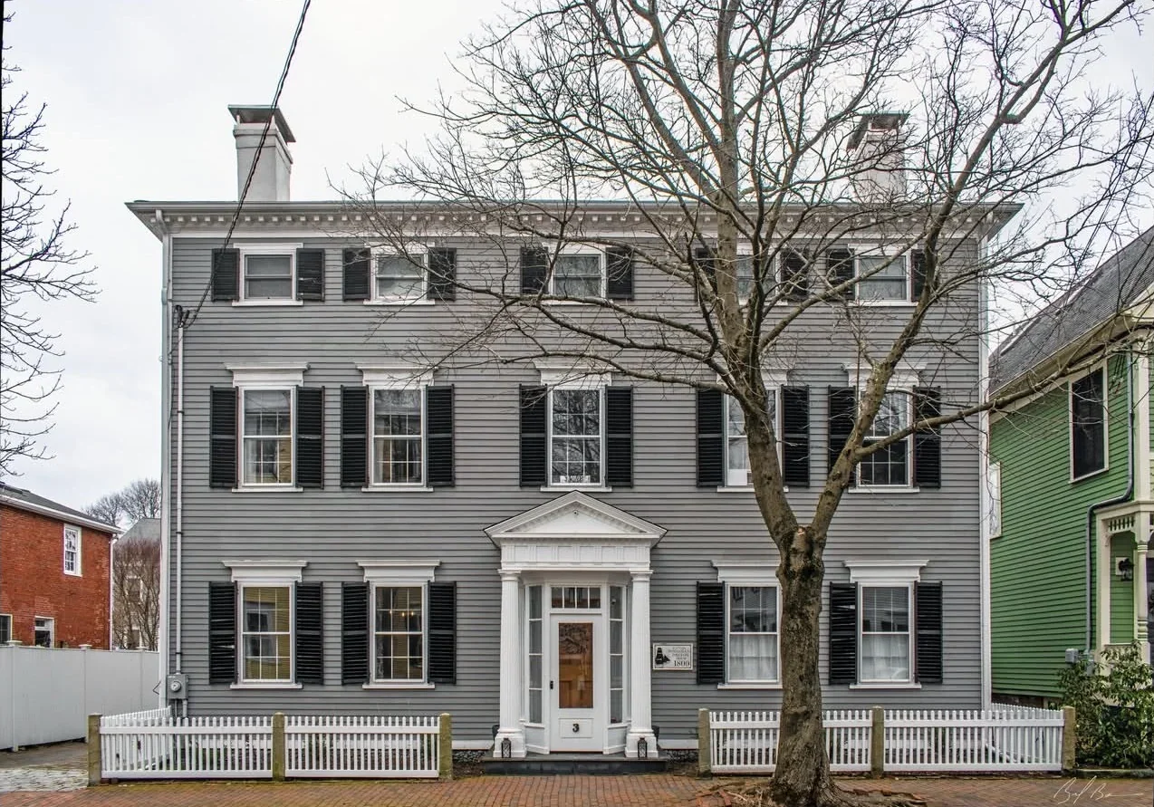
Federalist home in Newburyport, MA
Newburyport, MA · Federalist · 3,524 sq ft · 4 bed / 3 bath · Built 1800 · Historic District
NEP Property Intelligence Summary
ConditionC1Fire ClassBFlood ZoneXOwnerIndividualOccupancyOwner-Occupied
Purchased2018 (8yr)Permits11 total · 4 in 5yrSystems3 updated · newest 0yrLiensClearAssessed$1.6MOcean0.3 miSurgeCat 2
EraPre-1940HistoricDesignatedRenovationRecent (5yr)CommercialNo Business ActivityRadonZone 1 — Highest
AES-256 encryption
US-hosted infrastructure
CCPA compliant
Customer data never sold or shared
Authoritative, primary sources
PostgreSQL — enterprise-grade infra