
Local Insights/Massachusetts
Massachusetts property intelligence
NE Provenance tracks 2,401,050 properties across 10 Massachusetts counties and 285 municipalities — with 430+ intelligence attributes per parcel assembled from 140+ independent data sources. The median Massachusetts property dates to 1961, with the oldest on record to 1601.

2,401,050
Properties
1961
Median Year Built
$528K
Median Assessed
7%
FEMA Flood Zone
Massachusetts1788
Massachusetts is the most complex property market in New England. With 351 independent cities and towns — each maintaining its own assessment rolls, permitting systems, and recording practices — there is no single source of truth for property data in the Commonwealth. NE Provenance solves this by assembling data from every municipality into a unified intelligence layer.
The state's housing stock spans four centuries, from 17th-century colonial homes in towns like Deerfield and Ipswich to modern high-rises in the Seaport District. Over 60% of Massachusetts homes were built before 1970, making accurate condition assessment essential for insurance, lending, and investment decisions. Our permit-derived condition estimates (C1–C6) provide maintenance insight that assessor records alone cannot.
Coastal exposure is a defining risk factor. Massachusetts has over 1,500 miles of coastline, with communities from Newburyport to Provincetown facing hurricane storm surge, sea level rise, and nor'easter damage. Inland, riverine flooding along the Connecticut and Merrimack rivers affects thousands of properties. Our platform maps every FEMA flood zone, SLOSH surge model, and SLR projection at the parcel level.
Property Landscape
2,401,050 properties across 10 counties
Property Types
Single Family
1,389,830
Condominium
245,610
Multi-Family
177,895
Two-Family
162,402
Institutional
144,948
Vacant Land
103,684
Commercial
76,842
Industrial
23,038
Construction Eras
Pre-1800
10,442
1800–1899
169,264
1900–1949
591,209
1950–1969
452,938
1970–1989
437,803
1990–2009
308,800
2010+
134,290
County Coverage
10 of 14 Massachusetts counties with full parcel intelligence
Middlesex
525,538
Properties
54
Municipalities
Worcester
319,374
Properties
60
Municipalities
Essex
267,264
Properties
34
Municipalities
Norfolk
246,382
Properties
28
Municipalities
Plymouth
216,488
Properties
27
Municipalities
Suffolk
210,132
Properties
4
Municipalities
Bristol
203,255
Properties
20
Municipalities
Barnstable
182,826
Properties
15
Municipalities
Hampden
165,425
Properties
23
Municipalities
Hampshire
65,875
Properties
20
Municipalities
Largest Communities
Top 20 municipalities by property count
Boston180,473 properties · 1920
Worcester47,409 properties · 1941
Springfield44,283 properties · 1948
Plymouth30,984 properties · 1981
Cambridge28,855 properties · 1915
Quincy28,287 properties · 1935
Lowell28,228 properties · 1940
Newton27,923 properties · 1930
Brockton27,173 properties · 1958
New Bedford26,726 properties · 1923
Lynn22,014 properties · 1920
Fall River21,844 properties · 1930
Haverhill21,675 properties · 1960
Framingham21,103 properties · 1960
Weymouth20,384 properties · 1953
Somerville19,058 properties · 1910
Taunton18,643 properties · 1968
Medford18,626 properties · 1921
Chicopee18,559 properties · 1955
Methuen17,320 properties · 1967

Authoritative Property Intelligence for New England
Risk-based analytics and due diligence for 4.7+ million residential and commercial properties across
Massachusetts, Connecticut, New Hampshire, Rhode Island, Maine, and Vermont.
What we cover in Massachusetts
Every property in our Massachusetts coverage area includes these intelligence layers — all assembled from independent sources, not resold assessor data.
Building & Site
Year built, square footage, construction type, roof material, foundation, lot dimensions, zoning, architectural style, and occupancy status.
Permits & Condition
Condition estimate (C1–C6) derived from permit timeline. System ages for electrical, plumbing, HVAC, and roof. 961,691 Massachusetts properties with permit data.
Risk & Hazards
Fire protection grade (A–E), FEMA flood zones (7% SFHA), storm surge, sea level rise, wind speed, seismic hazard, wildfire, radon, and vacancy risk.
Environmental
Wetlands proximity, dam exposure, contamination records, historic designation, conservation lands, and environmental justice indicators.
Ownership & Valuation
Owner name and entity type, deed chain with sale prices, mortgage and lien analysis, assessment breakdown, and NEP Market Value Indication.
Neighborhood
Fire station distance, school districts, demographics, median income, utilities, and community resilience indicators.
Explore the intelligence for yourself
Open a Property Wallet for a real New England property. With over 4.7 million similar records across all six New England states, see how it fits into your workflow.
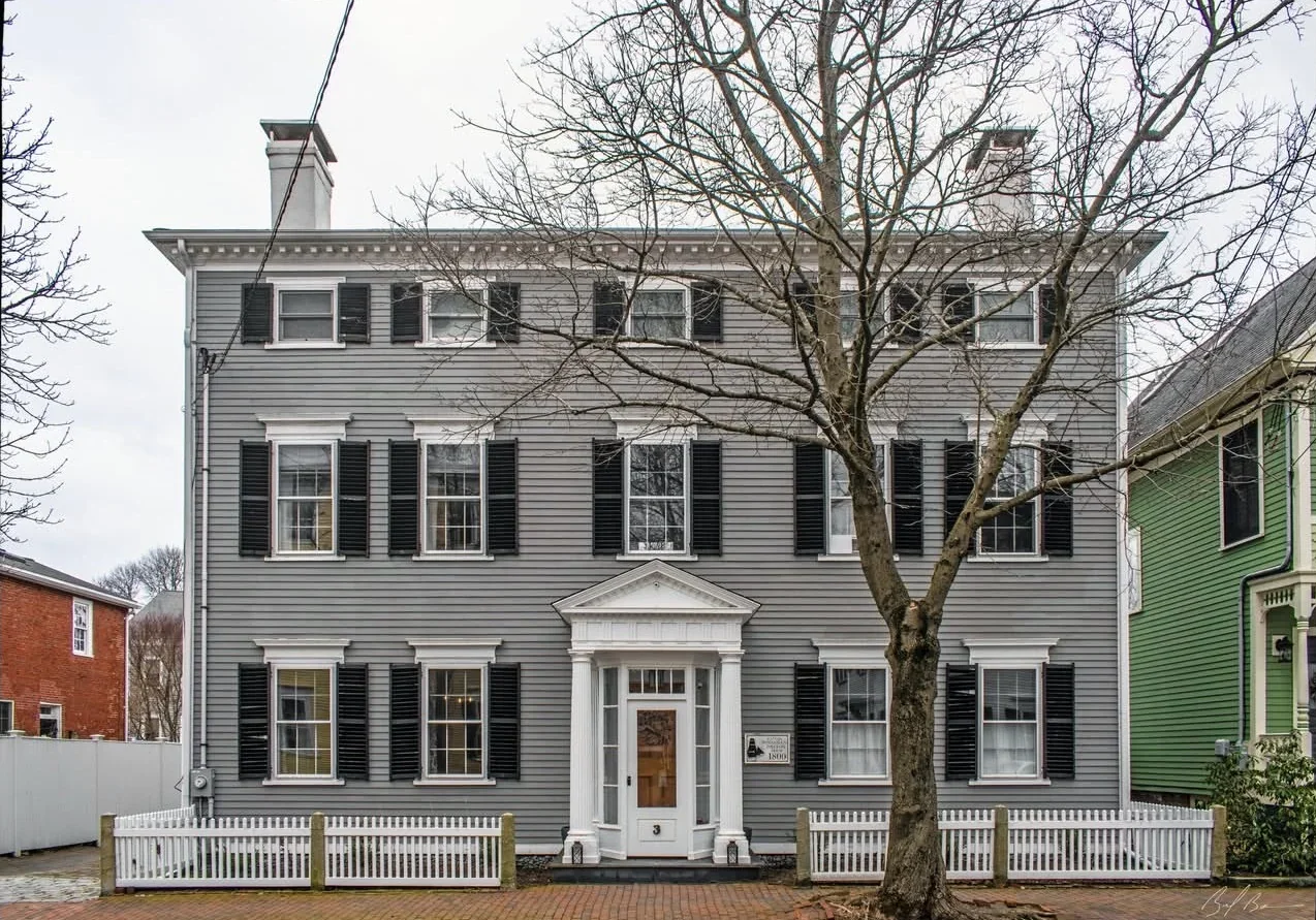
Newburyport, MA · Federalist · 3,524 sq ft · 4 bed / 3 bath · Built 1800 · Historic District
NEP Property Intelligence Summary
ConditionC1Fire ClassBFlood ZoneXOwnerIndividualOccupancyOwner-Occupied
Purchased2018 (8yr)Permits11 total · 4 in 5yrSystems3 updated · newest 0yrLiensClearAssessed$1.6MOcean0.3 miSurgeCat 2
EraPre-1940HistoricDesignatedRenovationRecent (5yr)CommercialNo Business ActivityRadonZone 1 — Highest
AES-256 encryption
US-hosted infrastructure
CCPA compliant
Customer data never sold or shared
Authoritative, primary sources
PostgreSQL — enterprise-grade infra